Maiden Of The Rock
A Hidden Maya City Above the Jungle
Xunan
tunich
Introduction
If you’re staying in San Ignacio, there’s one place that always comes up; and once you go, you’ll understand why.
Xunantunich isn’t just another ruin. It’s a quiet, powerful reminder of Belize’s deep history, sitting high above the Mopan River with views that stretch all the way into Guatemala.
From my experience, it’s one of those places that feels alive, fresh, sometimes crowded but not rushed, just you, the jungle, and something ancient watching back.
What Does Xunantunich Mean?
- Meaning: “Maiden of the Rock” or “Stone Woman”
- Language: Yucatec Maya (with Mopan Maya influence)
- Pronunciation: Shoo-nan-too-nich
The name comes from a local legend people claim to have seen a ghostly woman dressed in white, with glowing red eyes, climbing the steps of El Castillo before disappearing into the stone.
History of Xunantunich
Xunantunich was once a thriving Maya city during the Classic Period (200–900 AD).
Timeline:
- 300 BCE: Early settlement begins
- 200–600 AD: Expansion as a trade and ceremonial center
- 700–900 AD: Peak activity and spiritual importance
- ~1050 AD: Gradual abandonment
Its location overlooking the Mopan River made it strategic for controlling trade routes.
The Foundation: Trade and Geography (300 BCE – 600 AD)
The story of Xunantunich begins long before its monumental architecture dominated the landscape.
Early Settlement (300 BCE): The first settlers recognized the value of the ridge where the city stands today. This elevated position was not just defensive; it was the ultimate strategic viewpoint overlooking the fertile valley and, crucially, the Mopan River.
Strategic Leverage: Controlling this point meant controlling the primary river highway that connected the inland resources and capitals (like the great power of Tikal) to the Caribbean trade routes.
Trade & Ceremony (200–600 AD): During this Classic Period expansion, the strategic ridge evolved. What began as a collection of settlements grew into a significant ceremonial and political center. The emerging elite class began using their economic leverage to fund the first major iterations of temples and palaces.
The Peak: Spiritual and Political Ascent (700–900 AD)
This period is perhaps the most fascinating and contradictory in the history of Xunantunich. While the great superpowers of Tikal and Calakmul to the west were beginning to collapse under the weight of the “Maya Terminal Classic Collapse” (roughly 800–900 AD), Xunantunich was entering its golden age.
The Big Shift (c. 750 AD): When the nearby city of Buenavista del Cayo (the previous regional power) began to wane, Xunantunich seized the mantle of authority. The elites executed a massive, ambitious building program that redefined the acropolis.
The Frieze of Power: The towering El Castillo pyramid (A-6) was heavily expanded. This is when the spectacular stucco friezes were added. These intricate carvings, including the seated rulers, sky-serpents, and birth imagery, were not mere decorations; they were the visual argument for the city’s profound spiritual and ancestral connection to power.
Peak Activity: During these two centuries, Xunantunich reached its apex. The plazas below were bustling centers of ritual, administration, and, of course, the commerce that flowed in and out of the Mopan River trade artery.
The End: Gradual Decline (1050 AD)
A Slow Departure: Unlike other Maya cities that show signs of sudden, violent warfare or catastrophe, the abandonment of Xunantunich appears gradual. By 900 AD, the Terminal Classic collapse was making itself felt even in the periphery. The powerful trade networks began to break down, and the centralized authority that managed the massive monumental projects dissipated.
The Final Retreat (c. 1050 AD): Evidence of the last, major elite activities disappears around 1000–1050 AD. The complex political machinery ground to a halt. The city center was left to the jungle, though local populations likely still visited, giving rise to the modern legend of the ‘Stone Woman’ that haunts the site.
What Was Life Like There?
Imagine this:
- Priests performing rituals at sunrise
- Ball games played in ceremonial courts
- Nobles living in elevated palace structures
- Trade flowing along the river below
This wasn’t just a ruin it was a living city, filled with movement, belief, and power.
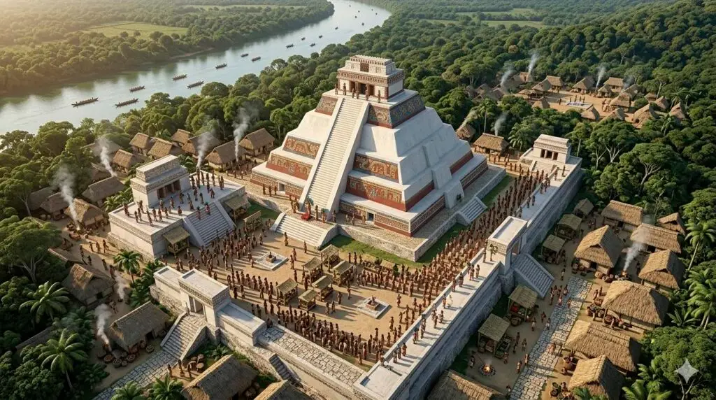
AI Rendering of Xunantunich
El Castillo (seen fully reconstructed with freshly plastered white walls in) wasn’t just a temple; it was a canvas of spiritual authority.
The critical trade artery. The Mopan River (seen winding through the lush valley below) connects the deep, resource-rich Mayan hinterlands to the Caribbean coastal networks.
The engine of peak activity. The expansive plazas (like Plaza A) and interconnecting stone causeways were the heart of public life. As captured in, these spaces were bustling with thousands of diverse Maya people: commoners and regional traders bartering goods in the marketplace, warriors patrolling the approaches, and elites moving between administrative palaces and ceremonial platforms, making the entire acropolis a humming center of political, religious, and commercial energy.
Location
Detail
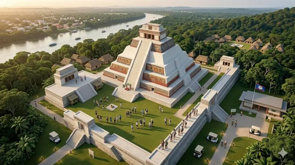
Xunantunich is located in the village of San Jose Succotz, just outside of San Ignacio. To reach the site, you must cross the Mopan River on a hand-cranked cable ferry, which is a signature part of the experience.
- Opening Hours : 8 AM - 4 PM
- Access : Once across the ferry, there is a short uphill walk or drive to the main entrance and the visitor center.
- Site Features : The archaeological park consists of several plazas and over 25 temples and palaces, with El Castillo being the most prominent structure.
Rise & Fall
Like many Maya cities, Xunantunich was caught between powerful kingdoms like Caracol, Naranjo, and Calakmul.
- Wars and shifting alliances weakened the region
- Environmental stress (droughts) likely played a role
- Population decline led to eventual abandonment
Even so, it outlasted many nearby cities, surviving into the Terminal Classic period.
When Was It Discovered?
- First documented in the 1890s by Thomas Gann
- Major excavations began in the 1900s
- Ongoing research continues today under Belize’s Institute of Archaeology
Main Structures at Xunantunich
🔺 El Castillo (The Crown Jewel)
- Height: ~130 ft (2nd tallest in Belize)
- Panoramic views of Belize & Guatemala
- Features intricate stucco friezes (sun, moon, Venus symbolism)
Climbing it is a must. It’s steep but worth every step.
Plazas & Structures
- 6 main plazas
- Over 25 temples and palaces
- Ball courts where the Maya played pok-a-tok
- Administrative and residential areas
My Favorite Spot (Local Insight)
Plaza A-III.
It’s quieter, slightly tucked away and when you stand there looking toward El Castillo, it hits different. You can actually imagine what life felt like here.
How to Get to Xunantunich
Location
- ~10 km (30 mins) from San Ignacio
- Near the Guatemala border
Option 1: Tour (Best Experience)
- Cost: ~$175 USD + tax
- Includes:
- Transport
- Guide
- Entrance fee
- Lunch
Best if you want full history + easy logistics
Option 2: DIY (Adventure Way)
- Bus from San Ignacio → $2.50 BZD
- Taxi → ~$8–10 BZD
- Ferry crossing (free)
- 20-minute uphill walk
This is what I did—and honestly, it made it feel more real
The Ferry Experience

Before you even reach the site, you cross the river on a hand-cranked ferry.
Simple. Old-school. And one of the coolest parts of the journey.
Entrance Fees & Info
- Entrance Fee: $10 BZD (~$5 USD)
- Hours: 8 AM – 5 PM
- Guide: Optional but recommended
What to Bring
- Water
- Sunscreen
- Comfortable shoes
- Hat
- Camera
It gets hot, and there’s a bit of climbing involved
Difficulty Level
Moderate
- Includes:
- Walking
- Stairs
- Heat exposure
Entrance Fees & Info
- Entrance Fee: $10 BZD (~$5 USD)
- Hours: 8 AM – 5 PM
- Guide: Optional but recommended
What to Bring
- Water
- Sunscreen
- Comfortable shoes
- Hat
- Camera
It gets hot, and there’s a bit of climbing involved
Difficulty Level
- Moderate
- Includes:
- Walking
- Stairs
- Heat exposure
Why Xunantunich Is Worth Visiting
- Less crowded than major Maya sites
- Climbable temples (rare)
- Real jungle setting
- Deep cultural significance
From my experience, it felt more personal than bigger sites like Chichén Itzá or Tikal you’re not just looking at history, you’re inside it.
Quick Travel Facts
- Time Needed: 2–4 hours
- Best Time to Visit: Morning (cooler + fewer people)
- Nearby Base: San Ignacio
It means “Maiden of the Rock” or “Stone Woman” in Maya.
Shoo-nan-too-nich.
Yes, but a guide adds historical context.
Get In Touch
If you’ve been, share your experience and let others see Belize through your eyes
One Response